Intermodal sections: train + bike
Things to see en route
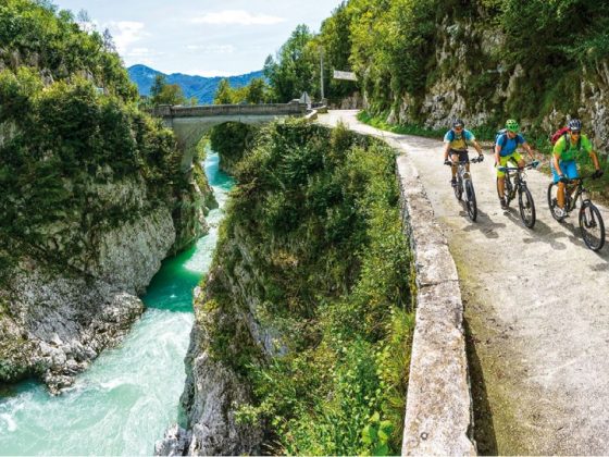
You are at Most na Soči, where the Idrijca plunges into the Soča: it is one of the main European prehistoric areas, as you will discover at the local Archaeological Museum.You follow the upper course of the Soča which, thanks to the many rapids, is paradise for those who love water sports like rafting, kayak, canoeing and hydro speed: it is a well-loved territory for the numerous fans of these sports. At Tolmin – known for its eighteenth century peasant revolt – you can find the Ethnographic Museum, the remains of a medieval castle and the magnificent Devil’s Bridge. Then you cross the river, thanks to the big Napoleonic arched stone bridge, reaching Kobarid, known for the famous retreat in November 1917, remembered in the local museum and the nearby St. Anthony’s memorial. From here those who are better trained can go up towards the source of the Soča, where there is the chance to visit the Boka waterfall. Now there is just one more hill towards Bovec. Then you return to Kobarid.
Description
Once we get off the train which has brought us from Jesenice (or Bled) to Most na Soči, we enter an important archaeological area, as shown by the many findings of tombs from the Iron Age: Sveta Lucija Culture. After a walk along the paths around the lake, where there is a beautiful view of the town, we go back up the green course of water towards its Karstic source located in the Triglav National Park. It winds in a wild environment made up of waterfalls, rapids and large dams which exploit some of its energy: now nature rules, offering thousands of interesting views. Near the important little town of Tolmin – the Tolmin Gorges are remarkable, located at the lower entrance of the Triglav National Park. They are characterised by a large mass wedged in among the faces, from the Devil’s Bridge, suspended at a height of 60 metres above the bright blue waters of the Tolminka and the so-called Dante’s Cave, where local legend has it that the poet found inspiration for his Inferno. Let’s remember that when we visit his tomb in Ravenna… Near Kobarid we cross the river thanks to a fine Napoleonic bridge – a stone arch – and then we can visit the town which became part of history during the Great War: don’t miss the museum which is dedicated to the war but above all to peace, focusing on mankind. We continue on the right bank passing through the towns of Žaga and Log Čezsoški, heading north towards Bovec, at least for those who have been in training. From the road you can admire the Boka waterfall, one of the most spectacular in Europe, 144 metres high and 18 metres wide. Finally you reach the Bovec plain, where the source of the Soča can be found. The route is a cul-de-sac and we can turn back towards Kobarid, continuing to enjoy the green waters of the Soča.
Conditions: almost all the route is on asphalted road with mixed traffic
Useful addresses
Adriabike_Brochure_1_2_EN.pdf


Tourist Office Tolmin
Petra Skalarja 4, 5220 Tolmin
T. +386 05 3800480
info@lto-sotocje.si
www.dolina-soce.com
Tourist Office Kobarid
Trg svobode 16, 5222 Kobarid
T. +386 05 3800490
info.kobarid@lto-sotocje.si
www.dolina-soce.com
Tourist Office Bovec
Trg golobarskih žrtev 8, 5230 Bovec
T. +386 05 3841919
info@bovec.si
www.bovec.si
Railway stations: Most na Soči